MONDAY, MARCH 13, 2023. BY BRAD WILMOT, WESTERN WEATHER GROUP.
A serious case of weather whiplash has hit California this winter, where a few extremely dry years have been followed by a seemingly endless parade of storms. Winter started fairly early in 2022, with the first decent rains arriving in mid-September. Computer models stayed pessimistic about the rest of the season, however, with La Niña conditions in place but weakening. Uncertainty in the forecast remained rather high though, in part due to the shifting ENSO conditions. Another storm arrived in early November and although moods were still dim about the rest of the season, a sliver of hope was brewing. Computer models finally started to catch on in December, and a persistent wet pattern was well on its way to California.
RECAP OF METEOROLOGICAL FALL/WINTER (SEPTEMBER – FEBRUARY)
The first storm of the season in mid-September ended up being rather wet across most of the Lodi area. The convective nature of the storm led to a wide range of rain totals, from around a quarter of an inch of water in some locations and up to an inch on others. Due to the timing of the system, the percent of normal rainfall for the time of the year spiked to well above 100%. As a reference, Sacramento averages no rain from July into early August, and that average only rises to around 0.05” by mid-September. The next storm in early November brought a more widespread heavy rain event to the region, with most locations reporting three-quarters of an inch to an inch of rainfall. Mostly dry conditions followed through the rest of November along with some rather cold nights, and multiple widespread freezes. A nearly constant train of storms then began to arrive in December. Measurable rain was recorded at the Galt-West weather station on 19 out of the 31 days in December. A memorable, intense band of precipitation then pushed through the region on New Year’s Eve. Daily rain totals ranged from around 3 to more than 4 inches in the Lodi area and were accompanied by damaging wind gusts in some spots, with gust speeds of up to 55mph recorded across the Lodi weather station network. This stormy pattern continued into mid-January with flooding then becoming a major concern.
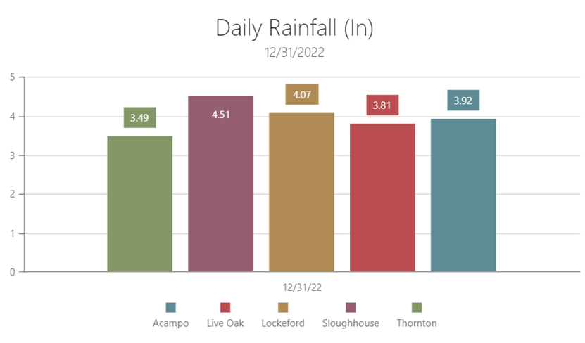 (Above: Daily rain totals from select locations on December 31, 2022.)

(Above: Maximum wind gust speeds from select locations on December 31, 2022.)
In late January and early February the atmosphere pulled off the gas a bit, and the Lodi area finally saw a few dry days in a row. Seasonal precipitation totals (from July 1) were already exceeding 20 inches in some spots by early February, and still well above normal values at the time. Drier conditions then arrived and allowed for some rather cold nights, with temperatures dipping below freezing across the area on at least a few occasions in early February. Temperatures stayed quite cool through the end of February, as a cold low-pressure system dropped southwards along the West Coast. This storm had frigid, arctic origins, and would end up bringing some snowfall to elevations just below 1000 feet across much of California.
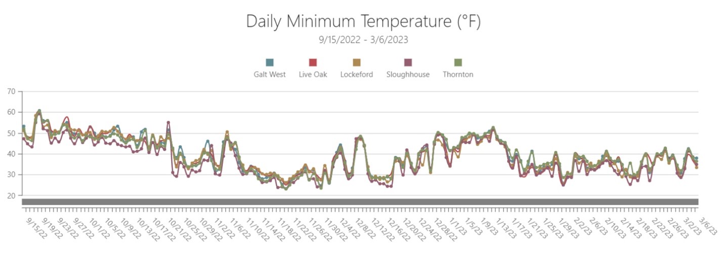
(Above: Daily minimum temperatures from select locations in the Lodi region since September of last year.)
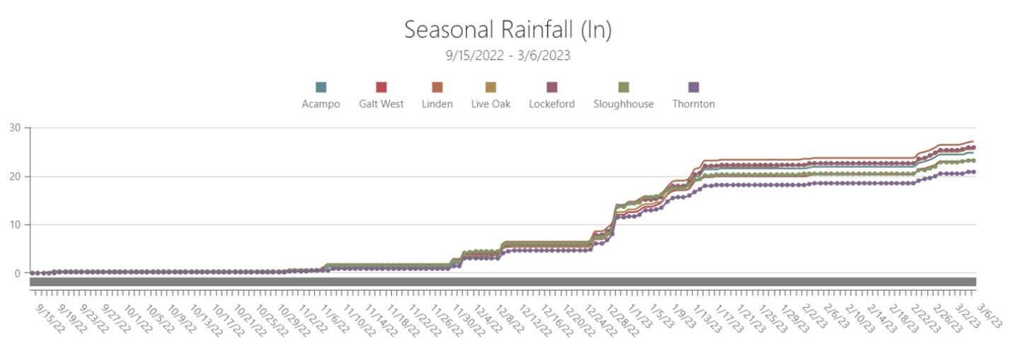
(Above: Accumulated seasonal rainfall totals from select locations in the Lodi region since September of last year.)
LOOKING AHEAD
Low pressure just off the West Coast looks to prevail and keep a rather moist pattern in place for the month of March in California. The European model shown below depicts this as the blue area in the upper left, a negative anomaly in pressure (500mb height). This type of pattern is excellent at pulling tropical moisture toward California, with heavy rainfall more likely with any systems moving toward the state.
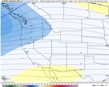
(Above: 500mb height anomalies modeled by the ECMFW from March into early April)
A couple of rather wet atmospheric rivers are currently looking to impact California in mid-March. Shown below is one computer model’s suggestion of the departure from average precipitation over the 30 day period from March 7th-April 7th. This shows that there is some potential for as much as 4-5” above the normal amount of rain in the Lodi area through early April.
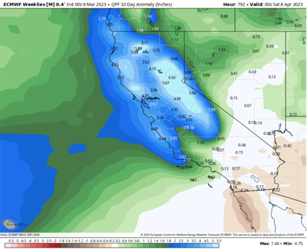
(Above: Precipitation anomalies modeled by the ECMFW from March into early April)
Seasonal rain totals remain well above normal values with around 20-26 inches across the Lodi area currently. This will eclipse normal values for the entire season and will be the first time in three years that the area, and most of California, has seen near to above-normal rainfall amounts. Here is how this year compares to previous years average rain totals across the Lodi network as of 3/6/2023:
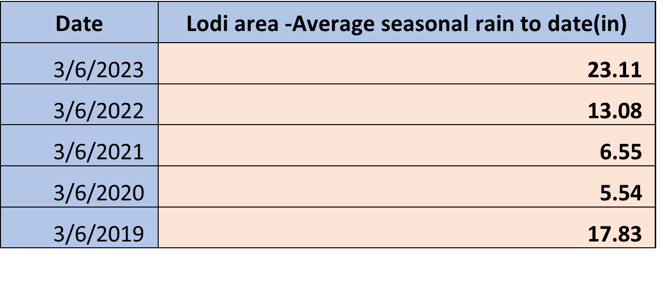 (Above: A table comparing seasonal rainfall totals(in inches) averaged across the Lodi weather station network, beginning July 1st and ending March 6th over the past 5 years)
This stormy pattern also looks to lead to lower overall temperatures. While some of these systems may have moist, warm tropical origins that could keep overnight lows rather mild, daytime highs look to be lower than normal. The model below depicts a possible departure from average temperatures of around 4 degrees below normal for the Lodi area and much of California.
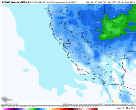
(Above: temperature anomalies (°F) modeled by the ECMFW from March into early April)
EXTENDED OUTLOOK
Beyond March, seasonal computer models offer little guidance in any obvious trends away from normal conditions for this time of the year. Average rainfall amounts for the area begin to drop heading into June, and models currently suggest that near-normal to slightly below amounts of rain are more likely in Lodi during the April-May-June timeframe. Temperatures show no obvious trend away from average values, leaving near-normal values as the most likely outcome during this spring. To summarize, current forecast models suggest a rather wet and cool March, with a return to near normal conditions from April into June.
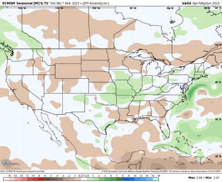
(Above: Precipitation anomalies (inches) modeled by the ECMFW for April-May-June)
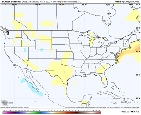
(Above: Temperature anomalies (°C) modeled by the ECMFW for April-May-June)
Stay tuned to Western Weather Group forecasts (which are available to all Lodi winegrowers via email and at lodi.westernweathergroup.com) to stay a step ahead of the weather. For more weather data, visit lodi.westernweathergroup.com to see forecasts and create reports from Lodi’s network of weather stations. For more information regarding weather instrumentation or forecasts, or to sign up for the daily email forecast, don’t hesitate to contact Western Weather Group at info@westernwx.com, 530.342.1700, or online at westernweathergroup.com.
Have something interesting to say? Consider writing a guest blog article!
To subscribe to the Coffee Shop Blog, send an email to stephanie@lodiwine.com with the subject “blog subscribe.”
To join the Lodi Growers email list, send an email to stephanie@lodiwine.com with the subject “grower email subscribe.”
To receive Lodi Grower news and event promotions by mail, send your contact information to stephanie@lodiwine.com or call 209.367.4727.
For more information on the wines of Lodi, visit the Lodi Winegrape Commission’s consumer website, lodiwine.com.
For more information on the LODI RULES Sustainable Winegrowing Program, visit lodigrowers.com/standards or lodirules.org.
